Left Cape, founded in 2022, is a direct successor to Geointelligence Systems, which was established in 2015. Building upon the substantial foundation laid by Geointelligence, Left Cape inherits the entire knowledge base and human capital of its forerunner. While Geointelligence Systems initially focused on services rooted in geointelligence, studying human activity through the exploitation and analysis of terrestrial observation in all its facets, especially in remote sensing and Aerial Vehicles, Left Cape channels this extensive expertise into new directions. Our mission now pivots towards environmental concerns and sustainable urban development. At Left Cape, we are dedicated to leveraging our rich heritage in geointelligence to create innovative solutions for greener, more sustainable cities, thereby addressing the pressing environmental challenges of our era.
The mission of Left Cape, building on the foundational objectives of Geointelligence Systems, is to streamline the flow of geospatial knowledge for sustainable urban and environmental solutions. We prioritize accurate data collection, efficient organization, and meticulous processing of this data into actionable information. Our analysis delves deep to extract meaningful insights, applying Artificial Intelligence algorithms to elevate this information into wisdom. This approach enables us to draw insightful conclusions that assist in understanding and addressing the complexities of sustainable city planning and environmental challenges. At Left Cape, we transform geospatial knowledge into tools for discerning and shaping a more sustainable and environmentally conscious reality
Left Cape, building on the solid foundation laid by Geointelligence Systems, has inherited an in-depth expertise in the use of drones for terrestrial observation. We have integrated this expertise with cutting-edge technologies in space-based remote sensing. This fusion not only enhances our data acquisition capabilities but also enriches our approach to processing and analyzing this data. By incorporating advanced big data technologies and artificial intelligence, Left Cape is adept at transforming raw data into actionable wisdom. Our approach encapsulates the convergence of these diverse yet complementary technologies, enabling us to extract more nuanced and insightful understanding from the data, crucial for developing sustainable and smart urban solutions.
Experience is a hard teacher because she gives the test first,
the lesson afterward.

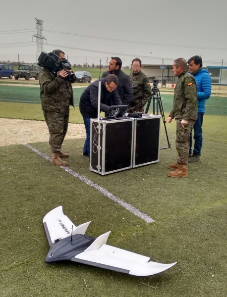
Development of a Command and Control System for Unmanned Aerial Vehicles. Responsible for the technical management of the development of said software, which has been acquired by the General Directorate of Armament and Material (DGAM, Ministry of Defense) under the RAPAZ project. This system operates with the GEODRONE platform (www.conyca.es) and is specialized in data collection for cartographic purposes. It is currently being used by the Geographical Center of the Army (CEGET) and by the Cartographic and Photographic Center of the Air Force (CECAF).

Technical direction of the Full Map Drone Solution project. Project developed by the company SRM Consulting (www.srmconsulting.es) that has an economic endowment of € 400,000, co-financed by the CDTI. The objective of this project is to offer the market a complete solution, based on a service, for obtaining and processing information derived from the different sensors that an Unmanned Aerial Vehicle can carry

Technical direction for the development of the project software "Recruitment of solutions, of a service of acquisition, maintenance and automation of topographic and cartographic bases by unmanned aerial means, TIERRA-2". This project is part of the "Civil UAVs Initiative", a strategic initiative of the Xunta de Galicia, aimed at improving efficiency in a wide range of services and activities carried out by the Galician public sector, through the use of aircraft and unmanned marine vehicles. One of the main objectives of the project is to provide the administration with algorithms based on Artificial Intelligence for the analysis of the images obtained by the same drones in order to automatically detect changes in the Galician landscape, and thus correctly apply territorial policies. This initiative has a budget that exceeds 150 million Euros. In particular Land 2 It has an approximate budget of two million Euros

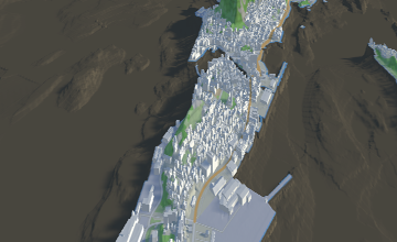
The last big project that Left Cape has involved in, consist in developing a new Terrain Server, providing world Information about DTM, Bathymetry, Satellite Imagery, Real Time Information such as traffic or soil temperature. This Terrain Server has been developed for www.osc.no, Norwegian company focused on Offshore Simulation Operations and smart cities.
This project has received funding from the European Union’s Horizon 2020 research and innovation programme under grant agreement nª 867732


In 2017, 335 natural disasters affected over 95.6Mill people, killing 9,697 and caused over €300bn in losses . Several regional and global emergency mechanisms exist to support disaster management, but they lack efficiency due to the unstructured existing management systems: unable to process information in real-time and to provide accurate tools for critical decision making based on objective information.
DRONECOP is the first integral general operation system for managing missions for combating natural disasters able to process data captured by a drone (video, photogrammetry) in real-time and automatically generate 3D cartography and georeferenced targets. DRONECOP is formed by: fixed wing drone, ground station, software with real-time data processing and Users and Project Management system. DRONECOP is an integral (software and hardware), fast (real-time data processing), accurate (<2cm of mapping error flying at 80km/h), and cost effective (1/3 of competing solutions) control and command system for managing natural disasters operations.